Tgrad GIS «Fiber Line»
The Tgrad graphical information system «Fiber Line» (GIS FL), developed by Technograd Plus for PJSC Rostelecom, is designed specifically to support input, processing and analysis of spatial-graphic and tabular data on trunk fiber-optic communication lines. The system stores records of cable structures in accordance with the regulations on territory of the Russian Federation.
Main features:
- Collection, storage and processing of cartographic information.
- Support of both vector and raster maps.
- The software supports the following basic operations with objects marked on the map:
- Edit\Create\Delete objects on the plan;
- Change the location of objects;
- Viewing of object parameters;
- Search for communication objects;
- Search for objects on the map.
- Collection, storage and processing of accounting information on the objects of linear-cable structures, placing them on a cartographic tile and edit their properties.
- Edit information of the cable.
- Clutch and fibre commutations management.
- Regenerative and amplyfing statiosn management.
- Fiber panels commutation management (ODF).
- Cabel integration analysis and management in accordance with the current connections and jack.
- Measurements filing and measurements filing combined with refloctograms.
- Optical distance visualization in the area of fibre damage with the detalization on the cabel slot.
- Option to save and print information on the fibre damage with the scheme of the slot.
- Cabel length management in the following dimensions: by cabel, pathway, optical length.
- Cabel length and dimension management by lines class, by the supplier name.
- Profound reporting tool set.
Object card
Graphical visualization of fiber cabel
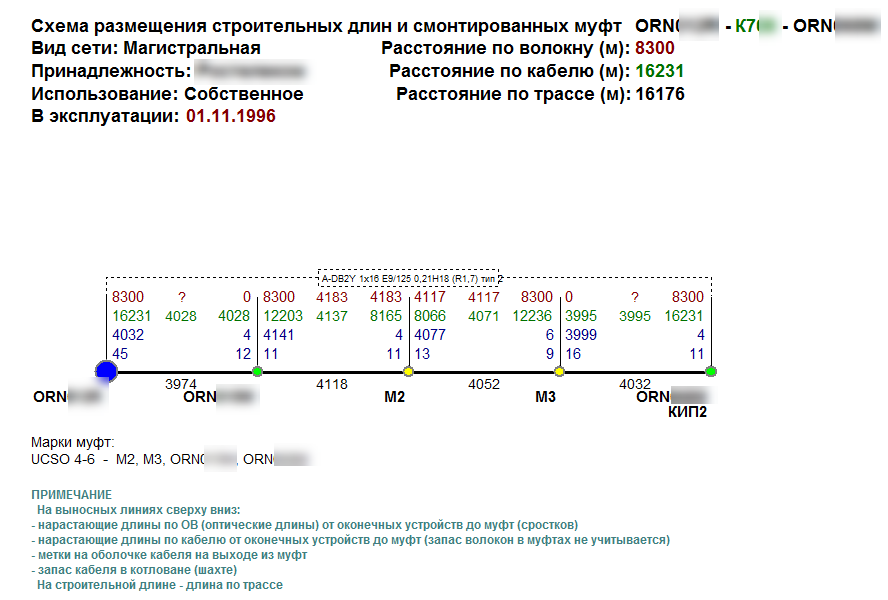
Delivery length and built clutches scheme
Node units commutations scheme
Cabel length fibres
Cabel lenth facilities evaluation
Spare cross section passport
Reflectogram management
Optical fibre damage evaluation


