Tgrad GIS Outside plant accounting system

A Tgrad GIS Outside plant accounting system collects and stores facilitie's data, designed based on Russian Federation regulations. 

Key Features:

  • Create and manage city map.
  • Add facilities with descriptions on the map to visualize the commutations.
  • Umlauted of data layers support.
  • Software supports Google, Yandex, open maps, satellite images.
  • Supports facilities location analysis.
  • Generates topologically right schemes of facilities.
  • Supports reach map and schematic network images. 
  • Edit and create facilities passports.
  • Reporting.
  • Advanced printing interface.
  • Access management system.

A Tgrad GIS Outside plant accounting system has two subsystems in its composition:

  • TECHNOGRAD. The schematic editor, provides the ability to create, edit, copy and save
    • Schemes of paired and optical cables
    • Passports of wells and switchboards
    • Frame diagrams for crosses
    • Input cards into the buildings
    • Schemes of trunk cables
    • Schemes of connecting lines
    • Schemes of cabinet areas

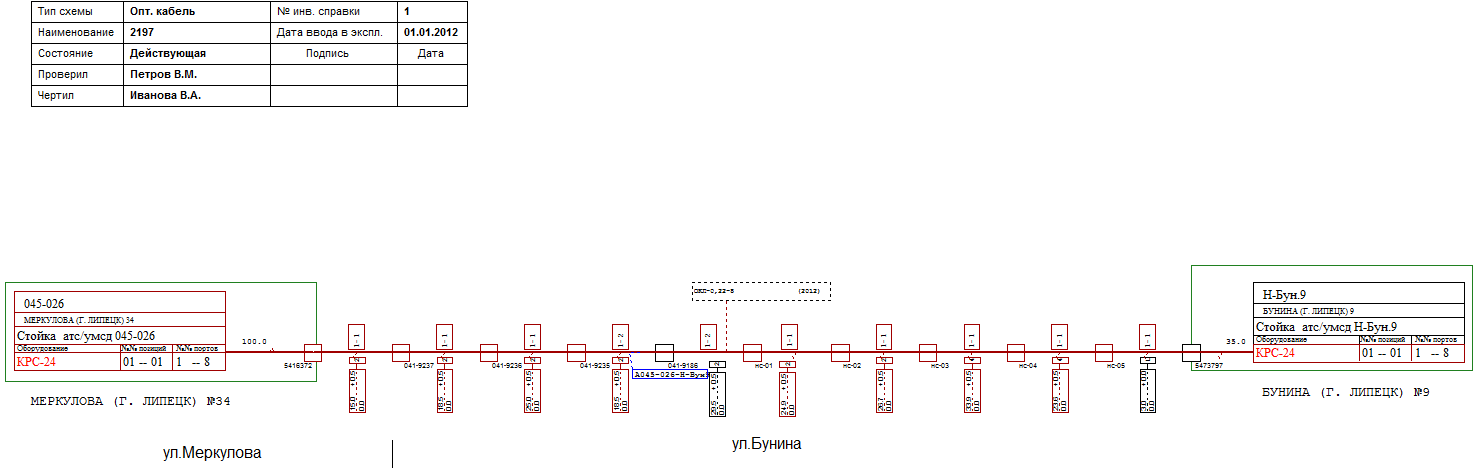
    A special tool is used to check the correctness of communication object diagrams, showing the number of errors and allocating them on the diagram.


Diagram of the optical cableDiagram of the optical cable


Passport of the well

Passport of the well


Entry card into the building

 Input card into the building


  • TECHNOGRAD. Geoinformatics (TECHNOGRAD GIS), contains plans for the territory and settlements with different details on the layers.

GIS

City plan


The subsystem TECHNOGRAD GIS implemented the ability to configure the printing a fragment of the map:


Printing card fragment disaggregated into sheets

Printing card fragment disaggregated into sheets for subsequent merge, taking into account the mapping scale, in the desired color or black and white form


Print a fragment at an angle

Print a fragment at an angle


Print selected objects

Print selected objects